| Coordinates WGS84 | 22°21'S, 144°43'E -22.35, 144.72 |
BM_Oc1901_1221_20
Title: A message stick from Queensland held in the British Museum
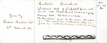
Description: Message stick made of wood (pine) with zigzag incised line on both sides. (British Museum catalogue entry).
Additional description on accompanying sketch: "Cylindrical stick of (imported) pine wood carved with longitudinal bands of zigzag. Message stick. Dalleburra Tribe. The translation given by the man who cut it is: "We want 'em walkabout. When we finish em walkabout along a bush, me come back."
Additional description on accompanying sketch: " [see also 'Message' field]
Message: Translation of the message stick “Me want ‘em walkabout. When me finish ‘em walkabout along a bush, me come back.’ [Notes written in 1901 by Robert Christison - from Ethdoc 903].
Date Created: 1901
Notes on date created: terminus ante quem
Item type: message stick in a collection
Subtype: traditional
State/Territory: QLD
Linguistic area 1: Chirila: Yirandali Austlang: L42 - Yirandali Glottolog: yira1239
Notes on linguistic areas: The message stick is associated with Lammermoor, Mitchell, Queensland.
Findspot: Mitchell/Lammermoor QLD.
Associated places: Flinders River, QLD.
From BM catalogue: "Christison acquired this collection of 20 objects from his Lammermoor station in Queensland’s Mitchell District. At the time he donated them to the British Museum, he described them as ‘Weapons of the Dalleburra tribe whose chief camping ground was round the waterhole Narkool on Lower Tower Hill Creek, which is the main source of the Thomson River, Queensland, Latitude 20o S longitude 144o E’ (Ethdoc 903)."
Curator's comments: "Message stick of the Dalleburra tribe, Narkool, (the name of their general camping ground round a waterhole of the same name on Lower Hill Creek, which is the main source of the Thomson River, Queensland, Latitude 20o S longitude 144o E) Mitchell District, North Queensland."
BM: "Made by Yirandali (aka Dalleburra)"
PK: Note that Yirandali and Dalleburra and in very different parts of Queensland, according to Austlang which lists Dalleburra as a synonym for Yirandali but not vice versa. Chirila does not list Dalleburra (Dalla) at all. Towerhill creek is in Yirandali country so I suspect this is the correct area.
Ideally, the coordinates should be dropped at Narkool, or failing that, Lammermoor Station.
In "Aboriginal Cultural Water Values – Galilee subregion A report for the Bioregional Assessment Programme", Narkool is listed as a waterhole on Yirendali country and described with "Central Camp site/Ceremonial Site/Burial site/Scar Tree" and " a main camp waterhole, ‘Lammermoor’ belonging to King Narkool aka King Barney", and "Narkool is a main camp waterhole, Lammermoor, belong to King Narkool aka King Barney."
Christoson's coordinates (Latitude 20o S longitude 144o E) are well north of Yirandali country but it could be that he is referring to the source of the Thomson river.
I have been unable to find coordinates for either Narkool or Lammermoor Station (which may no longer exist or its name may have changed). I have given coordinates for Towerhill Creek.
Cultural region: Production ethnic group: Yirandali (aka Dalleburra)
Dimension 1: 131mm Dimension 2: 10mm Dimension 3: 8mm
Materials: pine wood
Techniques: incised
Source types: museum collection
Date collected: Acquisition date: 1901
Institution/Holder file: The British Museum object identifier: Oc1901,1221.20
Collector: Donated by: Robert Christison
Curator's comments: "‘Message stick of the Dalleburra tribe, Narkool, (the name of their general camping ground round a waterhole of the same name on Lower Hill Creek, which is the main source of the Thomson River, Queensland, Latitude 20o S longitude 144o E) Mitchell District, North Queensland (Carved from imported pine). Translation of the message stick “Me want ‘em walkabout. When me finish ‘em walkabout along a bush, me come back.’ [Notes written in 1901 by Robert Christison - from Ethdoc 903]."
Coordinates: 22°21'0.100800"S,144°43'7.100400"E (-22.350028, 144.718639)
Media copyright: The British Museum British Museum Creative Commons (CC BY-NC-SA 4.0)
Notes on coordinates: Approximate coordinates for Towerhill Creek
IRN: EOC10347
Notes: OT: There's a "Bibliography" field in the BM metadata, don't know if it's relevant: National Museum of Australia 2015 p.139; Sculthorpe et al. 2015 p.175, fig.56
PK: Two additional images requested from BM on 15 November 2016 and linked by PK. Description field updated.
1.12.23 NR: Bibliographic references: "Sculthorpe et al. 2015 / Indigenous Australia: Enduring Civilisation (p.175, fig.56); National Museum of Australia 2015 / Encounters. Revealing Stories of Aboriginal and Torres Strait Islander Objects from the British Museum (p.139)." 1.12.23 NR: checked against BM online catalogue.
Media Files:
Data Entry: Olena Tykhostup, Piers Kelly, Nitzan Rotman
Related Entries: BM_Oc1901_1221_16, BM_Oc1901_1221_19


