| Coordinates WGS84 | 22°21'S, 144°43'E -22.35, 144.72 |
BM_Oc1901_1221_19
Title: A message stick from Queensland held in the British Museum
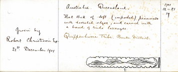
Description: Message stick of soft (imported) wood (pine), with serrated edges and carved with a band of lozenges.
Date Created: 1901
Notes on date created: terminus ante quem
Item type: message stick in a collection
State/Territory: QLD
Notes on linguistic areas: The message stick is associated with Lammermoor, Mitchell, Queensland. Findspot: Mitchell/Lammermoor QLD. Associated places: Flinders River, QLD. "Message stick of the Quippenburra tribe, Flinders River, Burke District, North Queensland (carved on imported pine)." [Notes written in 1901 by Robert Christison - from Ethdoc 903].
Dimension 1: 106mm Dimension 2: 15mm Dimension 3: 4mm
Materials: pine wood
Source types: museum collection
Date collected: Acquisition date: 1901
Institution/Holder file: The British Museum object identifier: Oc1901,1221.19
Collector: Donated by: Robert Christison Curator's comments: "'‘Message stick of the Quippenburra tribe, Flinders River, Burke District, North Queensland (carved on imported pine).’' [Notes written in 1901 by Robert Christison - from Ethdoc 903]." Acquisition notes: "Christison acquired this collection of 20 objects from his Lammermoor station in Queensland’s Mitchell District. At the time he donated them to the British Museum, he described them as ‘Weapons of the Dalleburra tribe whose chief camping ground was round the waterhole Narkool on Lower Tower Hill Creek, which is the main source of the Thomson River, Queensland, Latitude 20o S longitude 144o E’ (Ethdoc 903)."
Coordinates: 22°21'0.100800"S,144°43'7.100400"E (-22.350028, 144.718639)
Media copyright: The British Museum British Museum Creative Commons (CC BY-NC-SA 4.0)
Notes on coordinates: Approximate coordinates for Towerhill Creek. PK: Ideally, the coordinates should be dropped at Narkool, or failing that, Lammermoor Station. In "Aboriginal Cultural Water Values – Galilee subregion A report for the Bioregional Assessment Programme", Narkool is listed as a waterhole on Yirendali country and described with "Central Camp site/Ceremonial Site/Burial site/Scar Tree" and " a main camp waterhole, ‘Lammermoor’ belonging to King Narkool aka King Barney", and "Narkool is a main camp waterhole, Lammermoor, belong to King Narkool aka King Barney." Christoson's coordinates (Latitude 20o S longitude 144o E) are well north of Yirandali country but it could be that he is referring to the source of the Thomson river. I have been unable to find coordinates for either Narkool or Lammermoor Station (which may no longer exist or its name may have changed). I have given coordinates for Towerhill Creek.
URL source 1: https://archive.org/stream/handbooktoethnog00brit#page/114/mode/2up
IRN: EOC10346
Notes: PK: No new British Museum images to add 1.12.23 NR: checked against BM online catalogue.
Media Files:
Data Entry: Olena Tykhostup, Piers Kelly, Nitzan Rotman
Related Entries: BM_Oc1901_1221_16, BM_Oc1901_1221_20


