| Coordinates WGS84 | 21°23'S, 117°04'E -21.38, 117.06 |
PMH234670_D1730_0
Title: A message stick passport issued by Ngarluma people to Yinjibarndi people offering moon fishing
Description: Carving, wood, elliptical, incised animal and plant and alphabetic designs Display title: Passports, marben In PMH documentation (PMR-24-142 Kelly 23-46DIST, p17), described as "2 Marben (passports)".
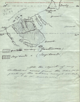
Message: From PMR-24-142 Kelly 23-46DIST_P26.png: "One side of the Passport issued by the Gnalluma tribe to the Ingibandi tribe to offer them a 'moon' fishing on the coast"
Creator of Object: Sender: Ngarluma Recipient: Yindjibarndi
Date Created: 1922
Notes on date created: Date of collection
State/Territory: WA
Notes on linguistic areas: PMH indicates "Kimberley". This is probably wrong since the sketch by Clement says it is "Gnalluma" (Ngarluma). 25.02.2024 PK: At the base of the sketched map of Ngarluma and Yindjibarndi country (PMR-24-142 Kelly 23-46DIST_P22) Clement writes: "All the objects of my collection come from the shaded parts of the above rough sketch map of W.W. Australia".
Dimension 1: 273mm Dimension 2: 44mm Dimension 3: 11mm
Institution/Holder file: Peabody Museum Harvard object identifier: 23-46-70/D1730
Collector: E. Clement
Coordinates: 21°23'4.200000"S,117°03'48.499200"E (-21.3845, 117.063472)
Notes on coordinates: Chirila centroid coordinates for Ngarluma
URL institution: https://collections.peabody.harvard.edu/objects/details/77172?ctx=d9a01303a70e4469bd21eccf9ee9c2d3c9a27e92&idx=0
Notes: In PMH documentation (PMR-24-142 Kelly 23-46DIST, p17), described as "2 Marben (passports)" PK: Relationships between Ngarluma and Yindjibarndi are described in 'Exile in the Kingdom' part 1: https://ictv.com.au/video/item/1063 See minute 29:39 to 32:14 This is the famous Wharlu story of the battle between the salt water snake and the freshwater snake. The letters T E A suggest (to PK) reproduction from tea rations issued by pastoralists
Media Files:
Data Entry: Piers Kelly
Related Entries: PMH234670_D1730_1


