| Coordinates WGS84 | 32°37'S, 121°34'E -32.62, 121.56 |
CPM1938P123F1
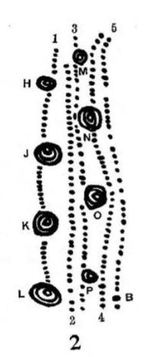
Title: Sketch of a message stick from C. Mountford's "Aboriginal message sticks" (1938), and reproduced in "The Advertiser" on 19 March 1938
Description: Sketch of a message stick on p. 123 of “Aboriginal message sticks” by C. Mountford
Message: Column 1(fig. 2): The small dots are spinifex" natives who are traveling towards, and expected at Cook before many days. The concentric circles, H, J, K, and L indicate the water-holes on which the travelling party will depend. H is called Mulgeru; J Nilida; K Mulunga; and L Wadiga. Column 2: A group of natives who are camping at Tarcoola. Column 3: The aborigines at Ooldea. Column 4: A second party of "spinifex" natives, who are expected to arrive at Cook in advance of those indicated in Column 1. M, N, O, P probabaly refer to water-holes, although this was not specified. Column 5: A small party of both sexes who have already arrived and are temporarily camping at Cook." (p. 123) From "The Advertiser": ""The dots represent natives traveling, the concentric circles indicate various waterholes along the route. The stick is sent to notify the tribes of a ceremony to which they are invited." (p. 12)
Creator of Object: Sender: "Karonie tribe" Recipient: "Ooldea tribe"
Date Created: 1938
Notes on date created: terminus ante quem
Item type: image of a message stick (artefact missing)
Subtype: traditional
State/Territory: SA
Linguistic area 1: Chirila: Galaagu Austlang: A2 - Kalarku Glottolog: kala1379
Linguistic area 2: Chirila: Mirniny Austlang: A9 - Mirning
Notes on linguistic areas: We have assumed Malpa/Galaagu as traditional owners of area occupied by the Karonie settlement. The "Ooldea tribe" is analysed as Mirniny. (Note, however, that Mirniny turns up twice in Chirila. One is over on the western edge of the Nullabor near Caiguna. The other is further east near Eucla. The Eucla Mirniny is the one referred to here.) We have assumed that "Ooldea tribe" is (eastern) Mirniny on the basis of the fact that the Ooldea soak is in this area at 30°24'29.0"S 131°49'42.0"E and the mission settlement is here: 30° 27′ 32.9″ S, 131° 50′ 8.21″ E. Tindale also refers to "Miming man of Ooldea who went to Esperance by train and found friendly southern people there". Note that the Ooldea settlement was used as a base for constructing the railroad. Harald wrote: "For doculects that that referred to as Mirning or the like the corresponding Glottolog variety can be either Kalarko [kala1379] kba Ngadjunmaya [ngad1258] nju It's debatable whether there should be a separate variety with that name. Mirning is also the name of a subgroup" Claire wrote: "So it looks like Glottolog includes 2 western Mirning languages but not the eastern-most one around Eucla, since the term Ngatjumaya is specifically for Western Mirning? I see in my tree I used "Mirniny", "Ngatjumaya" and "Eucla", and a number of Noongar varieties; I didn't have data for inland varieties."
Semantic domains: sd_activity_travel, sd_ceremony, sd_journey, sd_person, sd_person_group, sd_place, sd_place_waterhole
Sources:
Collector: Mr. Allen Musgrave ("I am indebted to Allen Musgrave for having, at my request, collected from the natives of the Nullabor Plains the sticks shown in figures 1, 5, 6 and 7, and having obtained the meanings of the above-mentioned three; also Mrs J. White, and Miss A. Lock for the loan of those shown in figures 10 and 3 respectively.)
Coordinates: 32°36'58.323600"S,121°33'45.068400"E (-32.616201, 121.562519)
Notes on coordinates: Chirila coordinates for Galaagu
URL source 1: https://archive.org/stream/TransactionsRoy62Roya#page/123/
URL source 2: http://nla.gov.au/nla.news-article30853888
Notes: This message stick from Karonie to Ooldea is possibly one of the longest journeys recorded for a message stick. Relevant coordinates: Karonie [origin]: 30°58'06.2"S 122°32'26.4"E (these are for Karonie train station) Mulgeru: (waterhole) Nilida: (waterhole) Mulunga: (waterhole) Wadiga: (waterhole) Tarcoola: 30°42'31.0"S 134°34'01.2"E (camp, town) Ooldea: (camp) Cook: 30°36'47.3"S 130°24'46.9"E (destination, coordinates from train station) A representation of the journey is here: https://www.google.com/maps/dir/Karonie,+Emu+Flat+WA/Ooldea+Soak,+South+Australia/-30.708612,134.566999/Cook,+Cook+SA/@-31.333652,123.5382089,2003436m/data=!3m2!1e3!4b1!4m21!4m20!1m5!1m1!1s0x2a53b083b95791c7:0x2fb180e9337c18e!2m2!1d122.533426!2d-30.966486!1m5!1m1!1s0x2ac44eb22804e7b5:0x2cee6fdfc2e15de9!2m2!1d131.82837!2d-30.4103699!1m0!1m5!1m1!1s0x2ac2f10a21b7d575:0x1d033655671ab000!2m2!1d130.4157831!2d-30.6124774!3e0 Also read the following for context: Bolam, A. G. [1923] 1978. The trans-Australian wonderland. Perth: University of Western Australia Press. and also: Dineen, Ann, and Peter Mülhäusler. 1996. "Nineteenth century language contact in South Australia." In Atlas of languages of intercultural communication in the Pacific, Asia, and the Americas, edited by Stephen A Wurm, Peter Mülhäusler and Darrell Tryon, 83-100. Berlin & New York: Mouton de Gruyter.
Media Files:
Data Entry: Olena Tykhostup, Piers Kelly


