| Coordinates WGS84 | 17°11'S, 145°49'E -17.18, 145.81 |
BM_Oc1933_0403_50
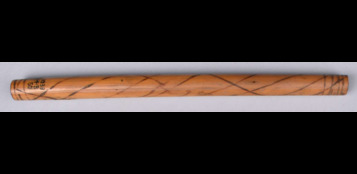
Title: A message stick from North Queensland held in the British Museum
Description: Message stick made of bamboo.
Date Created: 1905
Notes on date created: terminus ante quem
Item type: message stick in a collection
State/Territory: QLD
Notes on linguistic areas: The message stick is associated with Mulgrave, North Queensland Register addition "Cairns district" Register addition "Malgrave".
Dimension 1: 181mm Dimension 2: 12mm Dimension 3: 12mm
Materials: bamboo
Techniques: incised
Source types: museum collection
Date collected: Acquisition date: 1933
Institution/Holder file: The British Museum object identifier: Oc1933,0403.50
Collector: Donated by: Mrs Florence M Walker Field Collection by: Derwent Vallance Curator's comments: "Register addition "Cairns district" Register addition "Malgrave". This object was one of a larger collection which the donor, Miss F M Walker, described as having been collected by her brother in north Queensland some ‘thirty years ago’. Without any direct information from Miss Walker’s brother, the registrar in 1933 recorded his opinion that the collection came from ‘?Malgrave, Cairns District’. It appears Malgrave was a misspelling of the locality Mulgrave, near Cairns." Acquisition notes: "Register information: 'Collected by donor's brother 30 years ago.'"
Coordinates: 17°10'36.598800"S,145°48'38.199600"E (-17.176833, 145.810611)
Media copyright: The British Museum British Museum Creative Commons (CC BY-NC-SA 4.0)
Notes on coordinates: Approximate point between Mt Bellenden Ker & Gordonvale, Queensland, per Google maps. This area falls under the Cairns District (Malgrave is probably a spelling mistake for Mulgrave). An article from 12 Mar 1892 - THE EXPLORER - Trove, re the fruits of Mt Bellenden Ker referring to the local tribes as "Mulgrave blacks" (https://trove.nla.gov.au/newspaper/article/19822037) The Mallanbarra along with the other coastal clans the mandiigalpi and the gulgibarra were known by Europeans as the Mulgrave river blacks which they feared when trying to establish the area which is now known as Gordonvale (https://www.cairns.qld.gov.au/experience-cairns/facts-figures-history/first-peoples-history). Please note: there's is also a locality named "Mulgrave" (20°01'39.7"S 146°59'17.9"E - Mulgrave is a rural locality in the Shire of Burdekin, Queensland) in QLD. It is located near Townsville, a bit far from the Cairns District.
IRN: EOC17840
Notes: PK: No more images to request from BM 5.12.23 NR: checked against BM online catalogue.
Media Files:
Data Entry: Olena Tykhostup, Nitzan Rotman

