| Coordinates WGS84 | 22°34'S, 149°03'E -22.56, 149.04 |
ANON1896P10F1
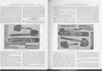
Title: Photo of a Queensland message stick from "The message sticks" (1896)
Description: Photo of two facets of one message stick on pp. 10-11 of “The message sticks.” (1896)
Message: This Message Stick was sent by the chief of the Conner's river tribe to the chief of the St. Lawrence river tribe asking him and his tribe to join in a Corroboree, to be held at the crossing or bridge on the Conner's river, and asking the chief of the St. Lawrence river to gather together all the game he could, as game were very scarce at their district. (pp. 10-11)
Creator of Object: Sender: the chief of the Conner's river tribe Recipient: the chief of the St. Lawrence river tribe
Date Created: 1870
Notes on date created: terminus ante quem
Item type: image of a message stick (artefact missing)
Subtype: traditional
State/Territory: QLD
Linguistic area 1: Chirila: Gabalbara Austlang: E45 - Gabulbarra
Linguistic area 2: Chirila: Guwinmal Austlang: E49 - Guwinmal
Notes on linguistic areas: The message stick is associated with "the country watered by the Conner's River, on the eastern coast of Queensland" (p. 10) This artefact, among the others from the same source, was obtained from "a tribe of aborigines inhabiting the country watered by the Conner's River, on the eastern coast of Queensland" (p. 10). We assume that "Conner's River" is intended to be "Connors River". The Connors River basin coincides with Gabalbara. Other groups, such as Mambura are on tributaries of Connors River. The object "was sent by the chief of the Conner's river tribe to the chief of the St. Lawrence river tribe asking him and his tribe to join in a Corroboree [...]". St Lawrence creek is situated firmly within Guwinmal country.
Semantic domains: sd_acculturation, sd_bridge, sd_ceremony, sd_game, sd_request_invitation_ceremony
Sources:
Collector: Mr. A. H. Fox, of the Bank of New South Wales, Taralga, brother of the gentleman who obtained them [sticks] from the aborigines (p. 10)
Coordinates: 22°33'41.605200"S,149°02'38.457600"E (-22.561557, 149.044016)
Notes on coordinates: Chirila centroid coordinates for Gabalbara
Media Files:
Data Entry: Olena Tykhostup, Piers Kelly


